As typhoon Ramil, the fourth typhoon to enter the country in 30 days, starts to threaten Luzon, nearly 108,000 urban poor families living as “informal settlers" along Metro Manila waterways are unsure which disaster will befall them first. Will it be another monster flood rushing across their makeshift communities? Or will it be forced evacuation and eventual relocation under a government program aimed at clearing the clogged waterways of the metropolis? In the wake of the double-whammy cyclones “Ondoy" and “Pepeng" that hit the country since late September, President Arroyo had ordered the forced relocation of urban poor communities living near waterways and other danger areas in Metro Manila and other parts of the country. In particular, the disastrous killer floods that engulfed wide swaths of Metro Manila at the height of “Ondoy" brought again to the fore the long-standing question about the role of these urban poor communities. The shanty-towns and their garbage block the flow of water, thus worsening the impact of typhoons, so goes the criticism. Extent of informal settlers along Metro waterways Growing urban poor populations live in the numerous nooks and crannies of Metro Manila – that much is true. According to records of the Metropolitan Manila Development Authority (MMDA), 544,609 families in Metro Manila are considered informal settlers as of September 2007 – the latest data so far. The number includes those families living in danger zones, government lands and private lands, and represents about 21 percent of the 2.6 million households in Metro Manila. Of this figure, 107,997 families (19.83 percent) live in danger zones, particularly along the rivers, creeks, tidewater estuaries (esteros) and other waterways, as well as along railways, roadways or sidewalks and aqueducts, and under bridges. The map below, created by GMA News Research, shows Metro Manila's network of rivers and creeks. Those in red are water bodies densely populated by informal settlers, based on data from the MMDA’s Flood Control Management Service (FCMS).
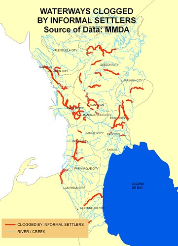
Metro Manila waterways clogged by informal settlers, based on data by the Metropolitan Manila Development Authority. Map by GMA News Research
Another map, more up close this time, shows waterways leading to Pasig River, which is the main drainage connecting Laguna Lake and Manila Bay. Many of these waterways also teem with informal settlers. These include Marikina River, San Juan River, Estero de Sta. Clara, Estero de Pandacan, Estero de Valencia, Estero de San Miguel and Estero dela Reina. The Manggahan Floodway itself – a flood control project of the Department of Public Works and Highways built in 1986 to absorb the excess water from Marikina River and divert it to Laguna Lake – is host to at least 1,800 informal-settler families, based on an MMDA FCMS estimate.
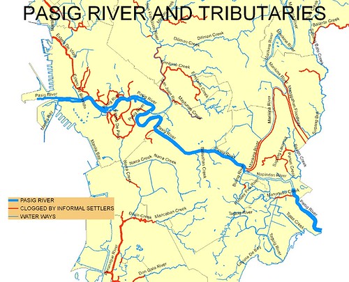
Pasig river and tributaries, showing areas populated by informal settlers. Map by GMA News Research
With the data provided by the MMDA on clogged waterways, GMA News Research identified 291 barangays that are at great risk from flooding due to their proximity to clogged drainage. The said barangays, with a population of more than 3 million residents as of the 2007 census, are shown below as areas shaded in blue stripes.
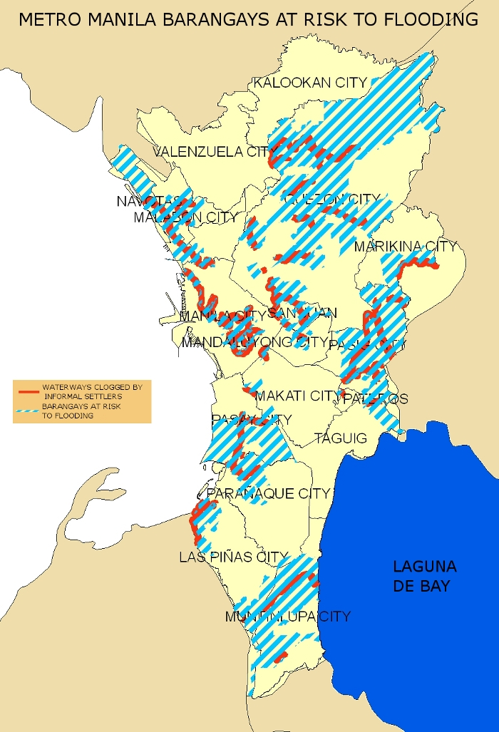
Metro Manila barangays at risk due to flooding. Map by GMA News Research
Even before “Ondoy," Mrs. Arroyo had issued Executive Order No. 803 in May 2009, creating the Metro Manila Inter-Agency Committee for Informal Settlers (MMIAC). The MMIAC is tasked with overseeing the relocation and housing program for informal settlers in Metro Manila. The head of the MMIAC is the MMDA, chaired by Bayani Fernando. Among its member-agencies are the National Housing Authority (NHA), Housing Urban Development Coordinating Council (HUDCC), Presidential Commission for the Urban Poor (PCUP), National Anti-Poverty Commission (NAPC), Department of Public Works and Highways (DPWH), Department of Interior and Local Government (DILG), Office of the President-External Affairs (OPEA), the Department of Budget and Management (DBM), and representatives of the urban poor communities. The government realizes that it would need a gargantuan effort – at least P30 billion in 10 years – to relocate the half-million-plus informal settlers in Metro Manila. But for now, the MMDA and other agencies are focusing on urban poor communities along the waterways. Targeted for relocation are the families who live in the priority areas which include: • Along San Juan river in Quezon City: Damayan Lagi, 11th Street, and Sta. Cruz • Along Estero de Tripa de Galina in Pasay City: Barangays 177, 135, 178, 179, 180, 181 and 182 • Old Balara (West and East side) on Commonwealth Avenue, Quezon City; and • Masambong and Manresa on Araneta Avenue, also in Quezon City. The NHA submitted 11 other priority areas for relocation: Buting, Pasig; Santolan, Mindanao Avenue, Balintawak, Quiapo, Nissan Tatalon, Pasay, Estero de Paco, R-10 Navotas, Market 3 Fishport of Navotas and Sta. Cruz. DPWH officials also said recently that the clearing of waterways would be carried out not just in Metro Manila but in other flood-prone areas of the country.
Juanico on the importance of relocation Meliton Juanico, an environmental planner and chairman of the Department of Geography at the University of the Philippines Diliman, stresses the importance of relocating the families living in the said danger zones because “they hamper the free flow of our drainage." Professor Juanico wants to give particular focus to monitoring easements, or strips of open land on both sides of a river bank. He says that in urban areas, the required easement under the Water Code is three meters on either side of the river bank, where there should be no building or establishment. “
Pero hindi naman na-iimplement yan - ang mga law sa atin, very lax. Magaganda ang batas pero hindi na-iimplement, hindi rin nai-evaluate (But these are not implemented; the laws that we have are very lax. These laws are good but they are not being implemented, and also not being evaluated)," he says. The UP professor mentions the Tullahan River, Diliman Creek, Culiat Creek, San Juan River, Taguig River, and Marikina River as among the waterways that should be cleared of informal settlers to lessen flooding. “In early times,
talaga namang binabaha (ang Manila), pero noon, walang tao sa ebb kaya dire-diresto lang ang tubig, madaling nadi-drain (In early times, Manila was being flooded too, but during those times, no people lived along the rivers’ ebb so the water flowed smoothly, and was easy to drain)," he says. Juanico adds that Mrs. Arroyo’s directive on the relocation of informal settlers is nothing new, but what is lacking is political will on the part of local governments. “
Para sa akin, dapat dagdagan ang kapangyarihan ng MMDA at LLDA. Dapat kasi ang approach sa problema ng informal settlers ay wholistic, inter-town, lahat ng concerned sa Marikina watershed." (For me, the powers of MMDA and LLDA must be expanded. The approach to the problem of informal settlers should really be wholistic, inter-town, and must involve all parties concerned with the Marikina watershed.)
An alternative view The urban poor communities that stand to be ejected from the said “danger zones" would like to offer another view. “Technically, there is nothing wrong with the relocation of the families living along the areas that the government deems as danger zones," says Jon Vincent Marin, spokesman of the urban-poor group Kadamay, in an interview by online news site Bulatlat. Urban poor organizations recognize the direct threat that typhoons bring to them, Marin says, but relocation is not enough. “If they will be relocated to areas where there are no social services and job opportunities, then there is something wrong with the relocation," he says. Marin insists that most relocated families would eventually return to the metropolis and live along the riverbanks and waterways, because conditions in the relocation areas are worse than along Metro Manila’s congested waterways. “We should all remember that the poor communities living along the riverbanks and waterways are only there because of poverty, lack of job opportunities, livelihoods, and social services," he says. “They are not dust that the government can sweep under the rug." Another urban poor leader affiliated with the women’s group Gabriela says, “If the victims are relocated to an area, but without livelihood and social services, it is no different from a calamity hitting the victims again."
- GMANews.TV with GMA News Research 
