

Filtered by: Topstories
News
Pagasa: Stay alert for possible return of ‘Pepeng’ to RP
(Updated 11:27 p.m.) With typhoon “Pepeng" still within the Philippine area of responsibility, another weather disturbance is threatening to enter the country's territory on Monday. State weather forecasters said the new disturbance may even pull "Pepeng" back to its course. Nathaniel Cruz of the Philippine Atmospheric, Geophysical and Astronomical Services Administration (Pagasa) said typhoon "Melor" is expected to enter Philippine territory on Monday later afternoon or early evening. "Melor" will be codenamed “Quedan" once it enters Philippine territory. Cruz said Pepeng may return to its earlier path because it was already interacting with "Melor." He explained that a high-pressure area is preventing Pepeng from moving toward the South China Sea and finally leaving the Philippines. “Isa sa nakikita ng ating forecasters maaring bumalik ito papunta uli ng Northern Luzon. Isa ito sa ating tinitingnan, una dahil sa kanyang interaction sa bagyong may international name na ‘Melor’ (One of the possibilities we are looking at is that it may return to Northern Luzon, because of its interaction with ‘Melor’)," Cruz said. He then urged officials in Ilocos and Cordillera to remain on alert for Pepeng’s possible return. In its 4 p.m. report, the National Disaster Coordinating Council (NDDC) said 14 people had died due to Pepeng - 12 in Benguet and two in Bicol. At least three were reported injured, including one in Kalinga and two in Benguet. Two people remained missing, including 13-year-old Amadeo de Vera from Pangasinan and one from Benguet, according to the NDCC. 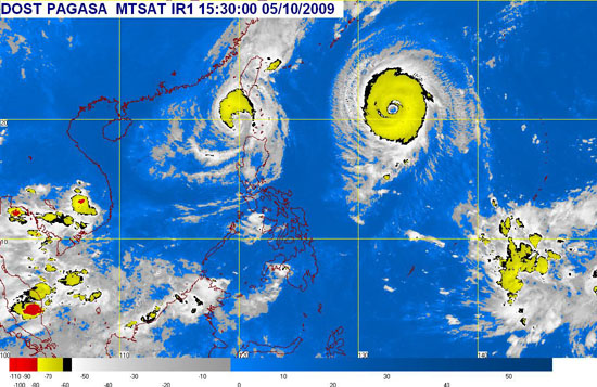
Pagasa’s satellite image of "Pepeng" (left) and "Melor" (right), which will be given a local name once it enters RP territory. Pagasa image as of 11:00 p.m. Sunday President Gloria Macapagal Arroyo ordered local government units to prepare for the entry of Melor and the possible U-turn of Pepeng. "The directive of the President is to be more prepared, to have forward planning and to improve disaster risk management," Press Secretary Cerge Remonde said in a radio interview. Remonde likewise urged pranksters to avoid spreading false information through text messages and Internet, as these may only create panic and sow fear among the public. Stationary "Pepeng" As of 11 p.m. Sunday, Pagasa said "Pepeng" remained almost stationary at 200 km north-northwest of Laoag City in Ilocos Norte because it was already interacting with Melor. Pepeng – which battered northeast Luzon on Saturday – weakened from 175 kph to 120 kph Sunday morning. It maintained its strength Sunday noon. Placed under Public Storm Warning Signal No. 3 are Batanes, northern Cagayan, Babuyan, Calayan Islands, Ilocos Norte, and Apayao. Under Signal No. 2 are Ilocos Sur, Abra, Kalinga, and the rest of Cagayan. Under Signal No. 1 are La Union, Benguet, Mt. Province, and northern Isabela. Pepeng is expected to be 260 kms north-northwest of Laoag City on Monday afternoon, 290 kms north-northwest of Laoag City on Tuesday afternoon, and 270 kms northwest of Laoag City on Wednesday afternoon. Earlier on Sunday, the Associated Press reported that Melor left the Northern Mariana Islands, Saipan, and Tinian. AP said the typhoon packed maximum sustained winds of 209 kilometers per hour (130 miles per hour) and was located at 298 kilometers (185 mi) northwest of Saipan and Tinian. It was moving at 27 kph (17 mph). Cruz warned that Melor is stronger than Pepeng or even tropical storm "Ondoy," which record rainfall submerged cities in Metro Manila and portions of Central Luzon and Calabarzon last September 26 and left close to 300 people dead. - GMANews.TV with AP
Find out your candidates' profile
Find the latest news
Find out individual candidate platforms
Choose your candidates and print out your selection.
Voter Demographics
LOADING CONTENT
