Typhoon "Melor" could be more than a super typhoon, but it could also spare the Philippines as it tended to make a "C-turn" heading for Japan, state weather forecasters said Monday. Expected to enter the Philippine area of responsibility late Monday, Melor may intensify into a "mega typhoon," warned the Philippine Atmospheric, Geophysical and Astronomical Services Administration (Pagasa). Pagasa’s weather sciences bureau chief Nathaniel Cruz said that Melor was already packing maximum sustained winds of 220 kilometers per hour. When typhoon "Pepeng" (international name: Parma) made a landfall in northern Luzon last Saturday, its intensity was 195 kph. Its velocity was down to 120 kph on Sunday, and remained so on Monday. Asked by radio dzBB anchor Arnold Clavio on what Melor could turn out to be, Cruz replied: "Baka mega typhoon (Perhaps a mega typhoon)." Cruz did not elaborate, but in the Philippines, the classification of cyclones according to degrees of intensity only reaches the 'super typhoon' level. [See: 'Pepeng' to hit N. Luzon Saturday as 'super typhoon'] Melor will be codenamed "Quedan" once it enters Philippine territory.
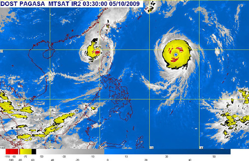 Pagasa's satellite image of "Pepeng" (left) and "Melor" (right), which will be given a local name once it enters RP territory. Pagasa image as for its 12 noon update on Monday
 Cruz said that Melor could change its course and head for Japan. "
Babalik at mag-U-turn
na parang C (It could return to its original path, and make a C-shaped U-turn)."
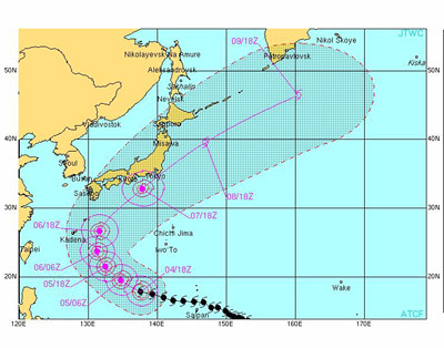 Melor's expected track, according to the US Navy Note the C-turn mentioned by Pagasa's Nathaniel Cruz US Navy image as of 11:30 a.m., Monday
 Still, Cruz reminded the public not to be complacent and prepare for Melor's possible wrath.
"Sa ating mga kababayan, lagi nating paghandaan. Huwag po yung iisipin natin na 'ang dami nang dumaan na bagyo, 'di naman nabuwal yung puno natin sa likuran,'" he said. (Filipinos should always be prepared. They should not have the mindset that they should be unmindful of any coming storm just because storms in the past did not even uproot trees on their backyard.)
Pepeng 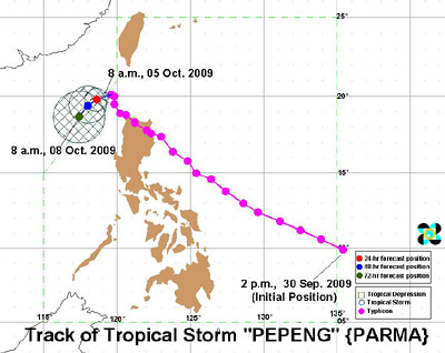
SOURCE: Pagasa, 11 a.m. image
Meanwhile, Cruz said Pepeng has weakened into a tropical storm but remains stationary as of 11 a.m. Monday. He said that Pepeng was located 230 km northwest of Laoag City, packing maximum sustained winds of 95 kph near its center with gustiness of up to 120 kph. "It is forecast to remain almost stationary for about three days as it interacts with typhoon Melor," he said. By Tuesday morning, it is forecast to be 240 km northwest of Laoag City, 270 km west northwest of Laoag City by Wednesday and 320 km west northwest of Laoag City by Thursday morning. Pagasa said storm signal number 2 remains hoisted in Ilocos Norte while areas under signal number 1 are: Ilocos Sur, Abra, Apayao, Batanes Group, Northern Cagayan, Calayan Islands and Babuyan Islands. Last Sunday, Cruz said Pepeng remained almost stationary and was moving very slowly because of its "interaction" with Melor. He added that Pepeng could even
return to its course, because of the said interaction. Cruz explained that a high-pressure area is preventing Pepeng from moving toward the South China Sea, finally leaving the Philippines. As of Sunday afternoon, data from the National Disaster Coordinating Council (NDCC) said Pepeng claimed a total of 14 lives, 12 in Benguet province and two in the Bicol Region.
- GMANews.TV 
