

Filtered by: Topstories
News
RP faces 2 cyclones as ‘Quedan’ enters territory
(Updated 11:56 p.m.) The Philippines - still reeling from the devastation of tropical storm "Ondoy" - now has two cyclones after typhoon "Quedan" (Melor) entered the Philippine area of responsibility Monday afternoon. In its 5 p.m. advisory, the Philippine Atmospheric Geophysical and Astronomical Services Administration (Pagasa) said "Quedan" continued to interact with tropical storm "Pepeng." "Quedan" - estimated at 1,020 km east-southeast of Basco, Batanes as of 11 p.m. - entered the country as Metro Manila and several nearby provinces continue to reel from the back-to-back onslaught of tropical storm "Ondoy" and typhoon "Pepeng," which left more than 300 people dead and millions worth of infrastructure and agriculture devastated. "Extreme Northern Luzon will experience stormy weather. The rest of Northern Luzon will have rains and gusty winds with moderate to rough seas. The rest of Luzon will be cloudy with scattered rainshowers and thunderstorms the rest of the country will experience partly cloudy to cloudy skies with isolated rainshowers or thunderstorms," Pagasa said. 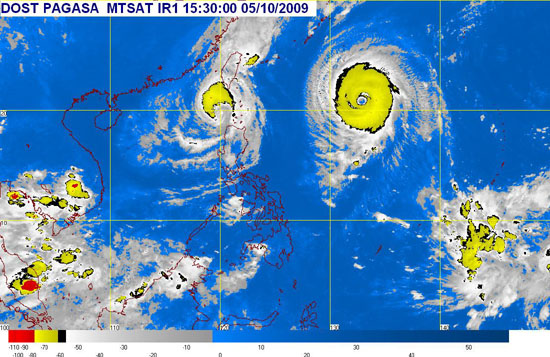
Pagasa's 11 p.m. update shows the satellite image of "Pepeng" (left) and "Quedan" (right), taken 8:30 a.m. Monday 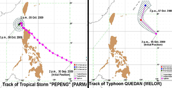 Pagasa tracks the courses of "Pepeng" and "Quedan" Pagasa said "Quedan" packed maximum sustained winds of 205 kph near the center and gustiness of up to 250 kph, and is forecast to move west-northwest at 26 kph. By Tuesday afternoon it is expected to be 860 km east-northeast of Basco, Batanes. "This disturbance is still too far to affect any part of the country," Pagasa said. On the other hand, "Pepeng" has maintained its strength as it remains almost stationary over the Luzon sea. As of 11 p.m., it was estimated at 220 km north-northwest of Laoag City, with maximum sustained winds of 105 kph near the center and gustiness of up to 135 kph. It remained almost stationary and is expected to be 180 km north-northwest of Laoag City by Tuesday afternoon, and 170 km northwest of Laoag City by Wednesday afternoon. By Thursday afternoon it is expected to be 180 km north-northwest of Vigan City. Ilocos Norte was under Signal No. 3 while Ilocos Sur, Abra, Apayao, Northern Cagayan, Calayan Group of Islands, Babuyan Group of Islands, and Batanes Group of Islands were under Signal No. 2. Under Signal No. 1 were La Union, Benguet, Mountain Province, Ifugao, Kalinga, and the rest of Cagayan. Pagasa reminded residents in low-lying areas and near mountain slopes under storm signals to take precautions against flash floods and landslides. It added those living along the coast in areas under signals #3 and #2 should be on alert against big waves generated by the tropical storm. - GMANews.TV
Pagasa tracks the courses of "Pepeng" and "Quedan" Pagasa said "Quedan" packed maximum sustained winds of 205 kph near the center and gustiness of up to 250 kph, and is forecast to move west-northwest at 26 kph. By Tuesday afternoon it is expected to be 860 km east-northeast of Basco, Batanes. "This disturbance is still too far to affect any part of the country," Pagasa said. On the other hand, "Pepeng" has maintained its strength as it remains almost stationary over the Luzon sea. As of 11 p.m., it was estimated at 220 km north-northwest of Laoag City, with maximum sustained winds of 105 kph near the center and gustiness of up to 135 kph. It remained almost stationary and is expected to be 180 km north-northwest of Laoag City by Tuesday afternoon, and 170 km northwest of Laoag City by Wednesday afternoon. By Thursday afternoon it is expected to be 180 km north-northwest of Vigan City. Ilocos Norte was under Signal No. 3 while Ilocos Sur, Abra, Apayao, Northern Cagayan, Calayan Group of Islands, Babuyan Group of Islands, and Batanes Group of Islands were under Signal No. 2. Under Signal No. 1 were La Union, Benguet, Mountain Province, Ifugao, Kalinga, and the rest of Cagayan. Pagasa reminded residents in low-lying areas and near mountain slopes under storm signals to take precautions against flash floods and landslides. It added those living along the coast in areas under signals #3 and #2 should be on alert against big waves generated by the tropical storm. - GMANews.TV Find out your candidates' profile
Find the latest news
Find out individual candidate platforms
Choose your candidates and print out your selection.
Voter Demographics
More Videos
LOADING CONTENT
