Nueva Ecija stands out among the provinces of Central Luzon as suffering the worst flooding from the relentless rainfall brought by typhoon "Pepeng," according to information from the Regional Disaster Coordinating Council. The RDCC reported that as of 7:30 a.m. Sunday, 28 of Nueva Ecija's 32 towns - or 87 percent - are submerged in floods.

Mapping by GMA News Research
A closer study of the map will show that although the flooding in Nueva Ecija is not as deep as in adjacent towns such as La Paz in Tarlac province (the deepest so far at 4-5 feet), it remains the most extensive among the Central Luzon provinces. Those in light green are towns with "affected" populations - still flooded but less than 1-foot deep. (See the map inset that contains color legends.) Among the deepest floods are in Cuyapo town, Nueva Ecija, which is adjacent to Pangasinan and suffers the same overflow of the Agno River due to the release of water from the San Roque dam. Those towns shaded as blue in the map are affected by floods that range from 1 foot to 5 feet, with a darker shade of blue for the deeper floods.
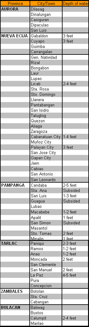
Aside from Nueva Ecija, all other provinces of Central Luzon except Bataan have been affected by floods, with 60 out of its 130 towns, or 46 percent, flooded due to Pepeng. [See table below.]
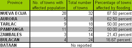
Of the country's top 10 flood-prone provinces as declared by the Department of the Environment and Natural Resources, four are in Central Luzon. These provinces are Pampanga, Nueva Ecija, Tarlac and Bulacan. Cold statistics are not easy to comprehend. But for anyone who has travelled the length and breadth of the plains north of Metro Manila in the past few days, one fact stands out: Central Luzon is living up to its reputation as one of the country's most flood-prone regions. GMA News Research will also post a flood map of northern Luzon as the data comes in.
- GMANews.TV and GMA News Research 

