

Filtered by: Topstories
News
Ramil still close to NLuzon landfall but might also veer away
(Updated 11:34 p.m.) After doing a slow snake dance for several days across the Pacific on its way to Northern Luzon, now feinting north, now near-stationary, now driving west, Typhoon Ramil is still expected to hit land along the northern Luzon coast on Friday night or Saturday morning, the state weather bureau said in its latest weather bulletin. But other national agencies tracking the storm think it has started to veer away to the north or northeast. Typhoon Ramil remained excruciatingly close to the northern Luzon coast, spotted at 150 kilometers east of Aparri, Cagayan and slowly moving west, according to the 11 p.m. weather bulletin of the the Philippine Atmospheric Geophysical and Astronomical Services Administration (Pagasa).
The weather agency's chief forecaster Nathaniel Cruz said Ramil has further weakened to maximum sustained winds of 120 kph near the center and gustiness of up to 150 kph. Asked why the typhoon is weakening and slowing down, Cruz said this is due to two factors: the effect of its being close to a mountainous land mass, and the overall atmospheric environment in the area. However, the Integrated Multi-Agency Tropical Cyclone Forecast map issued at 10:00 p.m. (Manila time) predicted that Ramil will tend to veer away from extreme northern Luzon in a northeasterly direction, toward Taiwan and the Ryukyu islands. The multi-agency map combines the forecasts of six weather forecasting agencies: those of the US Joint Typhoon Warning Center (JTWC), the Japan Meteorological Agency (JMA), the Hong Kong Observatory (HKO), the Korean Meteorological Administration (KMA), China’s National Meteorological Centre (NMC), and the joint Fujian-Taiwan China Meteorological Administration (CMA).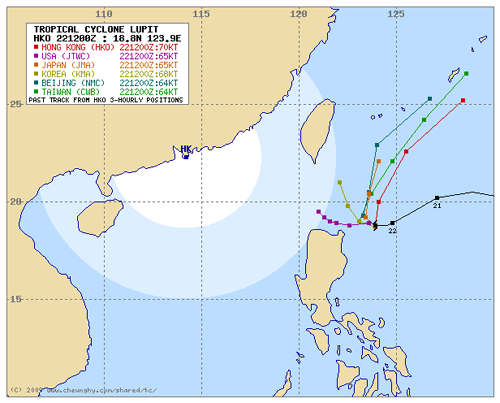
Public storm signal No. 3 remains hoisted over Batanes, Cagayan, Babuyan Islands, Calayan Island, Apayao and Ilocos Norte. Under signal No. 2 are Ilocos Sur, Kalinga, Isabela, Abra, and Mountain Province. Signal No. 1 now includes only Ifugao, Benguet, La Union, Nueva Vizcaya, Quirino and northern Aurora. Public storm signals elsewhere have been lowered. Pagasa likewise said that three dams continue to release water as of posting time, namely Pantabangan dam in Nueva Ecija and the Binga and Ambuklao dams in Benguet. – Andreo C. Calonzo and Jun Verzola, GMANews.TV (For details about the current status of various dams, see: Status of Monitored Major Reservoirs in Luzon.)
Pagasa track of Typhoon Ramil as of 8:00 p.m., 22 October 2009. The current position is indicated as a red dot. www.pagasa.dost.gov.ph
The weather agency's chief forecaster Nathaniel Cruz said Ramil has further weakened to maximum sustained winds of 120 kph near the center and gustiness of up to 150 kph. Asked why the typhoon is weakening and slowing down, Cruz said this is due to two factors: the effect of its being close to a mountainous land mass, and the overall atmospheric environment in the area. However, the Integrated Multi-Agency Tropical Cyclone Forecast map issued at 10:00 p.m. (Manila time) predicted that Ramil will tend to veer away from extreme northern Luzon in a northeasterly direction, toward Taiwan and the Ryukyu islands. The multi-agency map combines the forecasts of six weather forecasting agencies: those of the US Joint Typhoon Warning Center (JTWC), the Japan Meteorological Agency (JMA), the Hong Kong Observatory (HKO), the Korean Meteorological Administration (KMA), China’s National Meteorological Centre (NMC), and the joint Fujian-Taiwan China Meteorological Administration (CMA).
Combined forecasts by six storm forecasting agencies of Typhoon Ramil's (Lupit) expected track as of 10:00 p.m. Manila time, 22 October 2009. www.cheunghy.com
Public storm signal No. 3 remains hoisted over Batanes, Cagayan, Babuyan Islands, Calayan Island, Apayao and Ilocos Norte. Under signal No. 2 are Ilocos Sur, Kalinga, Isabela, Abra, and Mountain Province. Signal No. 1 now includes only Ifugao, Benguet, La Union, Nueva Vizcaya, Quirino and northern Aurora. Public storm signals elsewhere have been lowered. Pagasa likewise said that three dams continue to release water as of posting time, namely Pantabangan dam in Nueva Ecija and the Binga and Ambuklao dams in Benguet. – Andreo C. Calonzo and Jun Verzola, GMANews.TV (For details about the current status of various dams, see: Status of Monitored Major Reservoirs in Luzon.)
More Videos
LOADING CONTENT
