

Filtered by: Topstories
News
Tsunami alert up over 19 PHL provinces after Japan quake
UPDATED 7:30 p.m. - State seismologists raised a tsunami alert over at least 19 areas in the Philippines on Friday afternoon after a magnitude-8.9 quake hit Japan, said to be the biggest to hit that country in at least 100 years. 19 Philippine provinces are facing the threat of tsunami, in red below: 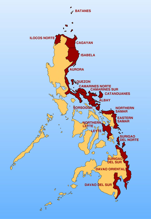
Click here for larger version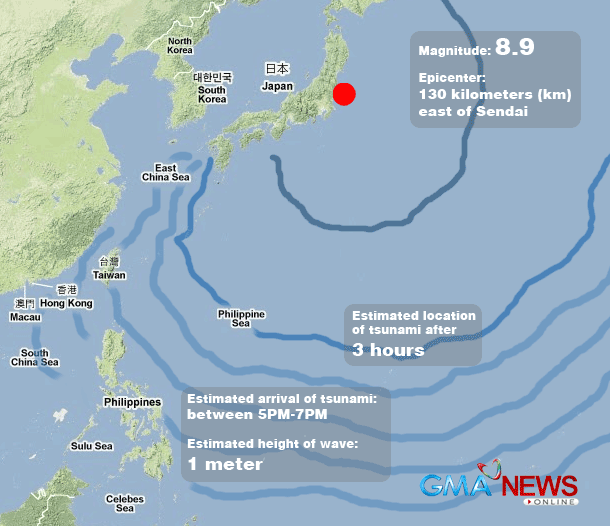
Click here for larger version The Philippine Institute of Volcanology and Seismology (Phivolcs) raised Tsunami Alert Level 2, warning of possible waves reaching Philippine shores between 5:00 and 7:00 p.m. on Friday. The Phivolcs advised the public to be on alert for unusual waves, which may be as high as one meter. On Friday afternoon, thousands of people living on the east coast of the Philippines have started to proceed to evacuation centers as they braced for the tsunami triggered by the massive earthquake in Japan. The mandatory evacuation was ordered by Malacañang for residents living 10 to 40 meters from the shoreline of Batanes, Cagayan, Ilocos, Isabela and 15 other provinces. At a press briefing in Malacañang on Friday, presidential spokesperson Edwin Lacierda said the alert level 2 raised by the Phivolcs means a mandatory evacuation of all residents near the shoreline. Lacierda said President Benigno Simeon Aquino III is urging all the affected residents to cooperate with authorities for their own safety. "Mahalaga po ito, nakikiusap kami sa mga kababayan na lumikas na. May sapat pa pong panahon all the local government officials have been notified," Lacierda said. He added that Aquino, who is in Singapore for a state visit, has been receiving updates from Philippine authorities. The United States Geological Survey (USGS) said the quake occurred at 1:46 p.m. near the east coast of Honshu, Japan. Phivolcs director Renato Solidum Jr. said in an interview on dzBB radio the areas in the eastern coastline include: Batanes Cagayan Ilocos Norte Isabela Quezon Aurora Camarines Norte Camarines Sur Albay Catanduanes Sorsogon Northern Samar Eastern Samar Leyte Northern Leyte Surigao del Norte Surigao del Sur Davao Oriental Davao del Sur Strong and big waves Solidum said the alert level also stemmed from a similar alert from the Pacific Tsunami Warning Center. "Ito pwedeng malaki at may pwersa (Such waves can be very big and powerful)," Solidum said, adding such waves may continue for hours. He advised people to stay away from the shorelines and not go to the coast to watch the tsunami. People in coastal areas should also go further inland, he added. WHAT IS A TSUNAMI? A Tsunami is a series of sea waves commonly generated by under-the-sea earthquakes and whose heights could be greater than 5 meters. It is erroneously called a tidal wave and sometimes mistakenly associated with storm surges. Tsunamis can occur when the earthquake is shallow-seated and strong enough to displace parts of the seabed and disturb the mass of water over it. Natural signs of an approaching tsunami: 1. A felt earthquake; 2. Unusual sea level change: Sudden sea water retreat or rise; 3. Rumbling sound of approaching waves. Source: Phivolcs website "Huwag maging usyoso pagpunta sa dalampasigan (Do not go to the shore to watch the waves)," he said. Earlier, Solidum also said residents with boats should secure the vessels in preparation for the waves. Contingency plans Various government agencies have readied contingency plans because of the tsunami alert. The national command of the Philippine National Police (PNP) has ordered the regional directors in 19 provinces to monitor the coastal areas and assist local governments and local disaster management councils. The local PNP in the provinces were also instructed to update the PNP national command every three hours. The Department of Social Welfare and Development has alerted its regional directors for possible relief efforts. The Department of Interior and Local Government has instructed the local disaster management councils to convene the PNP and Bureau of Fire Protection. The Department of Foreign Affairs, meanwhile, is closely monitoring the situation of the Filipinos in Japan. The DFA hotline for Japan-related concerns is (632) 843-4646. The Philippine Embassy in Tokyo and consulate in Osaka were ordered to assist all affected Filipinos.
Click here for larger version
Click here for larger version The Philippine Institute of Volcanology and Seismology (Phivolcs) raised Tsunami Alert Level 2, warning of possible waves reaching Philippine shores between 5:00 and 7:00 p.m. on Friday. The Phivolcs advised the public to be on alert for unusual waves, which may be as high as one meter. On Friday afternoon, thousands of people living on the east coast of the Philippines have started to proceed to evacuation centers as they braced for the tsunami triggered by the massive earthquake in Japan. The mandatory evacuation was ordered by Malacañang for residents living 10 to 40 meters from the shoreline of Batanes, Cagayan, Ilocos, Isabela and 15 other provinces. At a press briefing in Malacañang on Friday, presidential spokesperson Edwin Lacierda said the alert level 2 raised by the Phivolcs means a mandatory evacuation of all residents near the shoreline. Lacierda said President Benigno Simeon Aquino III is urging all the affected residents to cooperate with authorities for their own safety. "Mahalaga po ito, nakikiusap kami sa mga kababayan na lumikas na. May sapat pa pong panahon all the local government officials have been notified," Lacierda said. He added that Aquino, who is in Singapore for a state visit, has been receiving updates from Philippine authorities. The United States Geological Survey (USGS) said the quake occurred at 1:46 p.m. near the east coast of Honshu, Japan. Phivolcs director Renato Solidum Jr. said in an interview on dzBB radio the areas in the eastern coastline include:
Find out your candidates' profile
Find the latest news
Find out individual candidate platforms
Choose your candidates and print out your selection.
Voter Demographics
