

Filtered by: Topstories
News
LPA off Mindanao intensifies into Tropical Depression Ramon
(Updated 11:36 a.m.) The weather disturbance east of Mindanao has intensified into a tropical depression before noon Monday, and was locally codenamed "Ramon." The Philippine Atmospheric Geophysical and Astronomical Services Administration said Ramon may bring rain to Metro Manila starting Thursday. "(The tropical depression) will have an indirect effect on Metro Manila. Current data show possible rains due to this tropical depression by around Thursday in Metro Manila," PAGASA said on its Twitter account. A report by the US Navy projected that the cyclone may make landfall as early as Wednesday. It may also hit Cebu, Negros and the Panay islands if it will not change directions. In another tweet, PAGASA said Ramon was estimated at 600 km east southeast of Hinatuan, Surigao del Sur as of 10 a.m., packing maximum winds of 55 kph. PAGASA forecaster Aldczar Aurelio said the cyclone is likely to hit northern Surigao by Wednesday morning. "Sa Miyerkules ng umaga tatama ito sa Northern Surigao (On Wednesday morning, it may hit Northern Surigao)," he said in an interview on dZBB radio. 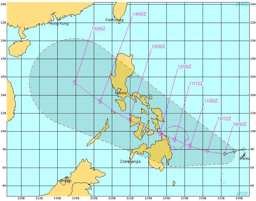 In its 11 a.m. advisory, PAGASA said Ramon may be 300 km east of Hinatuan, Surigao del Sur Tuesday morning and 60 km east southeast of Surigao City Wednesday morning. By Thursday morning, it is forecast to be in the vicinity of Iloilo City. Ramon may bring five to 20 mm per hour of rain (moderate to heavy) within its 200-km diameter, PAGASA said. Late last month, the country was struck by Typhoons Pedring and Quiel. Records from the National Disaster Risk Reduction and Management Council (NDRRMC) as of early Monday showed that the death toll from the cyclones has reached 102 and that damage to property has breached the P15-billion mark. Earlier, PAGASA forecaster Ben Oris said their models indicate Ramon may affect Hinatuan and may move west-northwest and threaten Visayas, Bicol, and even Central Luzon. "Tatawid ito kalupaan kung maging bagyo. Maaring Visayas o Bicol, maaring ganyan, Central Luzon and then sa susunod na 24 hours west-northwest na (Once it becomes a cyclone, it may make landfall and move west-northwest. It may cross the Visayas or Bicol, or even Central Luzon)," he said in an earlier interview on dzBB radio. — RSJ, GMA News
Courtesy of the US Navy
Find out your candidates' profile
Find the latest news
Find out individual candidate platforms
Choose your candidates and print out your selection.
Voter Demographics
LOADING CONTENT
